-
Land Cover Satellite 2016 Prod2

 Myanmar
21 tháng 5, 2019
Nguồn: MODIS-based Global Land Cover Climatology - Geometry calculation...
This is the Land Cover & Land Use data (2016) collected by Satellite imagery utilizing MODIS-based Global Land Cover Climatology - Geometry calculation through ESRI ArcMap...
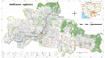
Myanmar
21 tháng 5, 2019
Nguồn: MODIS-based Global Land Cover Climatology - Geometry calculation...
This is the Land Cover & Land Use data (2016) collected by Satellite imagery utilizing MODIS-based Global Land Cover Climatology - Geometry calculation through ESRI ArcMap...
-
Land Cover Satellite 2010 Prod2
Myanmar
21 tháng 5, 2019
Nguồn: MODIS-based Global Land Cover Climatology - Geometry calculation...
This is the Land Cover & Land Use data (2010) collected by Satellite imagery utilizing MODIS-based Global Land Cover Climatology - Geometry calculation through ESRI ArcMap...
-
Thailand industrial estates
Thailand
21 tháng 6, 2016
Nguồn: Industrial Estate Authority of Thailand....
Data taken from the IEAT on all industrial estates in Thailand as of 2015. Used on the OD Mekong Thailand Land page: https://opendevelopmentmekong.net/topics/land-thailand
-
Các khu kinh tế tại các tỉnh của Việt Nam
Viet Nam
21 tháng 6, 2016
Nguồn: UNIDO. Economic zones in the ASEAN....
 Một số khu công nghiệp và khu kinh tế ở mỗi tỉnh của Việt Nam, dựa trên một bản đồ từ Bộ Kế hoạch và Đầu tư được nêu trong báo cáo của UNIDO. Đối chiếu với bản đồ trên trang OD...
-
Phnom Penh urban sprawl timeline (2003-2013)
Cambodia
6 tháng 12, 2015
Nguồn: Landsat NASA 2003/13 http://landsat.gsfc.nasa.gov/
 Landsat satellite images are presented in this dataset of Phnom Penh detailing land use change in the year 2003 and 2013. Dataset were provided to Open Development Cambodia...
-
Pursat communal land use planning (CLUP) atlas 2009
Cambodia
18 tháng 4, 2017
Nguồn: Ministry of Land Management, Urban Planning and Construction...
 Pursat communal land use planning(CLUP) atlas (Chamraeun Phal, Kbal Trach, Me Tuek, Phteah Rung, Prongil, Roleab, Ta Lou, Tnaot Chum commune) is communal land use planning...
-
Koh Kong communal land use planning (CLUP) atlas 2009
Cambodia
18 tháng 4, 2017
Nguồn: Ministry of Land Management, Urban Planning and Construction...
 Koh Kong communal land use planning(CLUP) atlas (Andong Tuek, Chrouy Pras, Smach Mean Chey, Stung Veng, Tma Sa, and Trapeang Rung commune) is communal land use planning...
-
Ratanakiri communal land use planning (CLUP) atlas 2009
Cambodia
18 tháng 4, 2017
Nguồn: Ministry of Land Management, Urban Planning and Construction...
 Ratanakiri communal land use planning(CLUP) atlas (Aekakpheap, Ka Choun, Pong, Sameaki, Serei Mongkol, and Toen commune) is communal land use planning extracted from 2009...
-
Siem Reap communal land use planning (CLUP) atlas 2009
Cambodia
18 tháng 4, 2017
Nguồn: Ministry of Land Management, Urban Planning and Construction...
 Siem Reap communal land use planning(CLUP) atlas (Chan Sar, Doun Peaeng, Leang Dai, Nokor Pheas , Popel, Srae Khvav, Svay Chek, Tayaek commune) is communal land use planning...
-
Kampong Speu commune land use planning (CLUP) atlas 2009
Cambodia
29 tháng 3, 2017
Nguồn: Ministry of Land Management, Urban Planning and Construction...
Kampong Speu commune land use planning(CLUP) atlas (Kiri Vaon, Moha Sang, Honorom, Prabei Mom, Prey Khmeng, and Yea Angk commune) is communal land use planning extracted from...
-
Kampong Cham communal land use planning (CLUP) atlas 2009
Cambodia
18 tháng 4, 2017
Nguồn: Ministry of Land Management, Urban Planning and Construction...
 Kampong Cham communal land use planning(CLUP) atlas (Chikor, Moung Riev, Roang, and Srak commune) is communal land use planning extracted from 2009 contained both detailed...
-
Mondulkiri communal land use planning (CLUP) atlas 2009
Cambodia
18 tháng 4, 2017
Nguồn: Ministry of Land Management, Urban Planning and Construction...
 Mondulkiri communal land use planning(CLUP) atlas (Dak Dam, Pu Chri, Saen Monourom, Srae Ampum, Srae Khtum, and Srae Preah commune) is communal land use planning extracted from...
-
Preah Sihanouk communal land use planning (CLUP) atlas 2009
Cambodia
18 tháng 4, 2017
Nguồn: Ministry of Land Management, Urban Planning and Construction...
Preah Sihanouk communal land use planning(CLUP) atlas (Angdoung Thma, Kampenh, Outreh, Samrong, and Tomnob Rolok commune) is communal land use planning extracted from 2009...
-
Kep communal land use planning (CLUP) atlas 2009
Cambodia
18 tháng 4, 2017
Nguồn: Ministry of Land Management, Urban Planning and Construction...
Kep communal land use planning(CLUP) atlas (Angkaol, Ou Krasar, and Pong Tuek commune) is communal land use planning extracted from 2009 contained both detailed current land...
-
Kratie communal land use planning (CLUP) atlas 2009
Cambodia
18 tháng 4, 2017
Nguồn: Ministry of Land Management, Urban Planning and Construction...
 Kratie communal land use planning(CLUP) atlas (Dar, Kbal Damrey, O Krieng, Ruessei Kaev, Saob, Srae Char, Svay Chreah, and Thmi commune) is communal land use planning extracted...
-
Agriculture land areas 2012
Cambodia, China, Lao People's Democratic Republic, Myanmar, Thailand, Viet Nam
22 tháng 6, 2016
Nguồn: ADB's Statiscal Database.
https://sdbs.adb.org/sdbs/...
Comparison of agriculture land with permanent crops, pasture or meadow in 2012 for the Lower Mekong countries. Collated for a visualization on the OD Mekong Land page:...
-
Agricultural and cropped land, 2012
Cambodia, Lao People's Democratic Republic, Myanmar, Thailand, Viet Nam
17 tháng 5, 2016
Nguồn: https://sdbs.adb.org/sdbs/
Downloaded from Asian Development...
Dataset of total Agriculture land area and percentage of total land, and cropped land area and percentage for 2012 in each Lower Mekong country. Compiled for a visualization on...
-
FAOSTAT: Lao People's Democratic Republic
Lao People's Democratic Republic
15 tháng 2, 2018
Nguồn: Food and Agriculture Organisation of the United Nations
This data set profiles the various country indicators for the Lao People's Democratic Republic by the FAO. There are datasets available on: Demographics, Agricultural Inputs,...
-
Myanmar land area by type, 2014
Myanmar
22 tháng 6, 2016
Nguồn: Myanmar Settlement and Land Records Department. Downloaded...
A selection of the 2014 data on the size of different land types. Collated for a visualization on the OD Myanmar Land page: https://myanmar.opendevelopmentmekong.net/topics/land
-
Registering property indicators, Laos
Lao People's Democratic Republic
22 tháng 6, 2016
Nguồn: Source: World Bank. Doing Business Report 2016....
Three of the Laos' property indicators from the World Bank Doing Business report, 2016. Collated for the Laos Land page: https://opendevelopmentmekong.net/topics/land-laos
You can also access this registry using the Giao diện lập trình ứng dụng (see Văn bản API).