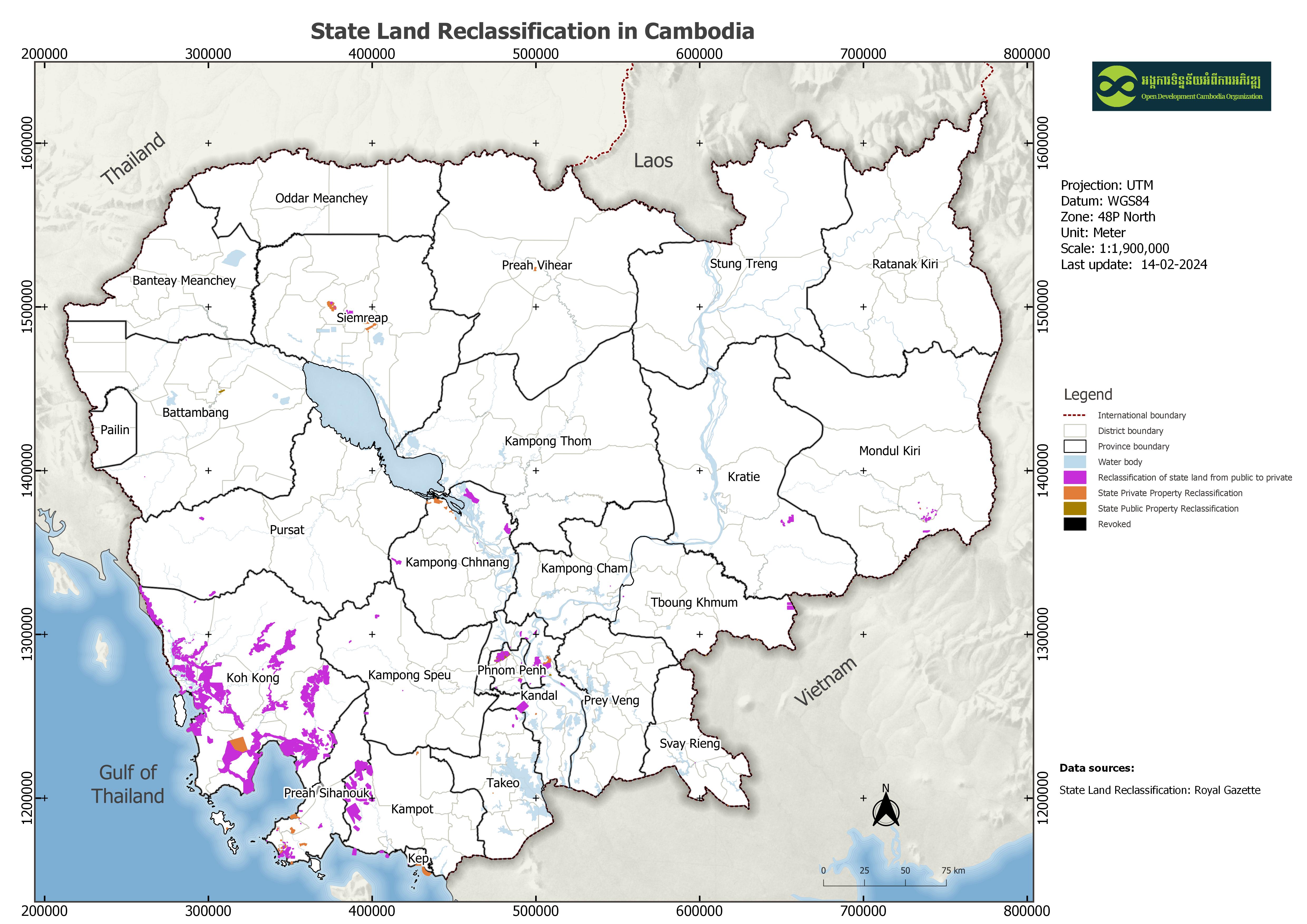
State land reclassification
Published by: Open Development Cambodia
Data Resources (7)
Data Resource Preview - State land reclassification
Thông tin khác
| Miền | Giá trị |
|---|---|
| Loại chủ đề của bộ dữ liệu |
|
| Ngôn ngữ |
|
| Hạn chế truy cập và sử dụng | By accessing this website or database, users agree to take full responsibility for reliance on any site information provided and to hold harmless and waive any and all liability against individuals or entities associated with its development, form and content for any loss, harm or damage suffered as a result of its use. |
| Cơ sở dữ liệu dịa lý |
|
| Các tọa độ ranh giới phía Tây | 103.60572241722225 |
| Các tọa độ ranh giới phía Đông. | 105.08582199660128 |
| Các tọa độ ranh giới phía Nam. | 10.539823299357336 |
| Các tọa độ ranh giới phía Bắc. | 11.666236964364654 |
| Hệ tham chiếu không gian | WGS 84 / UTM zone 48N (EPSG:32648) |
| Độ chính xác định vị | Since the dataset was collected mostly through digitization of the scanned maps in the law document, there will inevitably be a few trivial spatial errors. |
| Độ chính xác thuộc tính | The accuracy depends on the source of the Royal Gazette of Cambodia. |
| Tính nhất quán logic | There is no known about the issues of consistency. |
| Tính đầy đủ | Completeness depends on the references that can be found by ODC's map experts, so this dataset requires further updating and monitoring. |
| (Các) quy trình thu thập và xử lý dữ liệu | This dataset is acquired by converting the scanned map to SHP format through a process done using GIS tools such as point coordinate input, georeference, and digitization. |
| (Các) nguồn | Royal Gazettes of Cambodia |
| Liên hệ | General Department of Royal Gazettes, Office of the Council of Ministers (OCM) Address: OCM, Friendship Building, 41 Russian Federation Blvd, Phnom Penh, Cambodia. Contact: Phone/Fax: (855) 23 212 490, E-Mail: info@pressocm.gov.kh, pressocm@gmail.com |
| Thông tin người tạo Metadata. | Metadata last updated on 2024-02-014. For inquiries contact: Open Development Cambodia, Email: contact@opendevcam.net, Website: http://www.opendevcam.net Address: 23B St. 606, Phnom Penh, Cambodia. |
| Thuộc tính | map_id: ID number to identify map, name: Area/Grantee name, category: Category of property statement , owner: Grantee who has the privilege, area (ha): area in hectare unit, village: village name, commune: commune name, district: District name: province: Province name; references: References of the dataset |
| Giấy phép | Creative Commons Attribution |
| Bản quyền | Yes |
| Phiên bản | 1.0 |
| (Các) Tỉnh |
|
| Các từ khóa | state public property,state private propetry,land classification |
| Ngày đăng tải | tháng 11 15, 2019, 03:08 (UTC) |
| Ngày chỉnh sửa, cập nhật | tháng 2 19, 2024, 04:55 (UTC) |