-
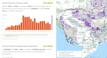
Retail fuel prices in Cambodia

 Cambodia
March 27, 2026
Source: The Ministry of Commerce: https://www.moc.gov.kh/kh/news?category=5
This dataset presents the retail prices of regular gasoline and diesel, expressed in Cambodian riels per liter, at fuel stations across the Kingdom of Cambodia. The data was col...
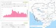
Cambodia
March 27, 2026
Source: The Ministry of Commerce: https://www.moc.gov.kh/kh/news?category=5
This dataset presents the retail prices of regular gasoline and diesel, expressed in Cambodian riels per liter, at fuel stations across the Kingdom of Cambodia. The data was col...
-
Community protected areas
Cambodia
May 4, 2026
Source: Royal Gazette from government of Cambodia, Sub-decree and Prakas,...
 This dataset contains data of community zones in the natural protected areas such as the national park, biodiversity conservation corridor, multiple use areas, wildlife sanctuar...
-
List of Oknha in Cambodia
Cambodia
May 4, 2026
Source: Royal Gazette of Cambodia
This dataset provides a comprehensive record of individuals appointed to the title of Oknha, Neak Oknha, and Lok Neak Oknha in the Kingdom of Cambodia, based on Royal Decrees pu...
-
Fisheries resource management data
Cambodia
May 27, 2025
Source: Prakas No.628 on 26.12. 2011 Prakas No.123 on14.03.2011 Prakas...
 The dataset provides information on fish sanctuary, community fishery, and flooded forest in Cambodia up to 2021. Geographic data is encoded in the WGS 84 zone 48 coordinate re...
-
Special economic zone in Cambodia (2006-2026)
Cambodia
April 23, 2026
Source: Royal gazette: sub-decree and decisions (2006-2023). Council for...
 This dataset describes the information of special economic zone (SEZ) in Cambodia from 2006 to 2026. The total number of 71 SEZs are recorded in point that data was collected fr...
-
Tree cover loss by dominant driver
Cambodia
April 10, 2026
Source: Global Forest Watch:...
 This dataset contained information about tree cover loss by the dominant driver in Cambodia from 2001 to 2024. The data were downloaded from Global Forest Watch and subsequently...
-
Forest-related greenhouse gas emissions in Cambodia
Cambodia
April 9, 2026
Source: Global Forest Watch:...
 This dataset presents the information on forest-related greenhouse gas emissions in Cambodia between 2001 to 2024. The data were downloaded from Global Forest Watch and subseque...
-
Plantations in Cambodia by provincial level
Cambodia
April 8, 2026
Source: Global Forest Watch:...
 This dataset shows the extent of tree plantations by species or type within Cambodia at the provincial level in 2000. It includes planted forests and agricultural tree crops est...
-
Postal code
Cambodia
January 15, 2026
Source: Ministry of Post and Telecommunications,...
This dataset contains official postal codes issued by the Ministry of Posts and Telecommunications for identifying postal areas across Cambodia, covering capitals, provinces, mu...
-
Tree cover by land cover class in Cambodia 2020
Cambodia
April 8, 2026
Source: Global Forest Watch: https://gfw.global/LCQlwv
 This dataset contained information about tree cover by land cover class in Cambodia in 2020. The data were downloaded from Global Forest Watch and subsequently uploaded to the O...
-
Registered indigenous communal land
Cambodia
January 22, 2026
Source: Sub-decrees, Remarks by Minister of Land Management Urban Planning...
 This dataset contains information on the land titles of the indigenous communities registered and issued by the Ministry of Land Management Urban Planing and Construction, from ...
-
Forest cover loss from fire
Cambodia
April 6, 2026
Source: Global Forest Watch:...
 This dataset presents information on forest cover loss caused by forest fires in Cambodia from 2001 to 2024. The data were downloaded from Global Forest Watch and subsequently u...
-
Casino location in Cambodia
Cambodia
April 3, 2026
Source: Commercial Gambling Management Commission of Cambodia:...
 This dataset provides geospatial information on casino locations across Cambodia, including company names, game of chance names, license types, addresses, geographic coordinates...
-
Major foreign investment projects in Cambodia
Cambodia
November 8, 2023
Source: Council for the Development of Cambodia (CDC): Royal Gazette of...
 The foreign investment project dataset has been established to provide relevantly practical information within Cambodia's investment projects flow, comprehending major foreign i...
-
Community forestry (2008-2017)
Cambodia
November 27, 2024
Source: The reference sources were taken from Prakas from Ministry of...
 This dataset describes the information of community forestry (CF) in Cambodia from 2008 to 2017. The total number of 339 CFs is recorded. The data was collected from many source...
-
State land reclassification
Cambodia
May 27, 2025
Source: Royal Gazettes of Cambodia
 This dataset contains information regarding the establishment of land as state public property and the reclassification to state private property of some areas in Phnom Penh, Ka...
-
Cambodian citizenships
Cambodia
March 11, 2026
Source: Mekong Independent:...
This dataset contains records of foreign nationals who were granted Cambodian citizenship through official announcements published in the Royal Gazette. It covers documents issu...
-
Asian elephant in Cambodia
Cambodia
March 10, 2026
Source: IUCN Biodiversity Assessment & Knowledge Team: Red List Unit:...
 This dataset provides the distribution of the Asian Elephant in Cambodia, derived from the International Union for Conservation of Nature (IUCN) Red List of Threatened Species. ...
-
Religion sites in Cambodia
Cambodia
February 12, 2026
Source: Geofabrik download server: https://download.geofabrik.de/asia.html
 This dataset contains geospatial information on religious sites across Cambodia, representing multiple faiths including Buddhism, Islam, Hinduism, and Christianity. The data wer...
-
Game of chance location in Cambodia
Cambodia
February 11, 2026
Source: Commercial Gambling Management Commission of Cambodia:...
 This dataset provides geospatial information on games of chance locations across Cambodia, including company names, game of chance names, license types, addresses, geographic co...