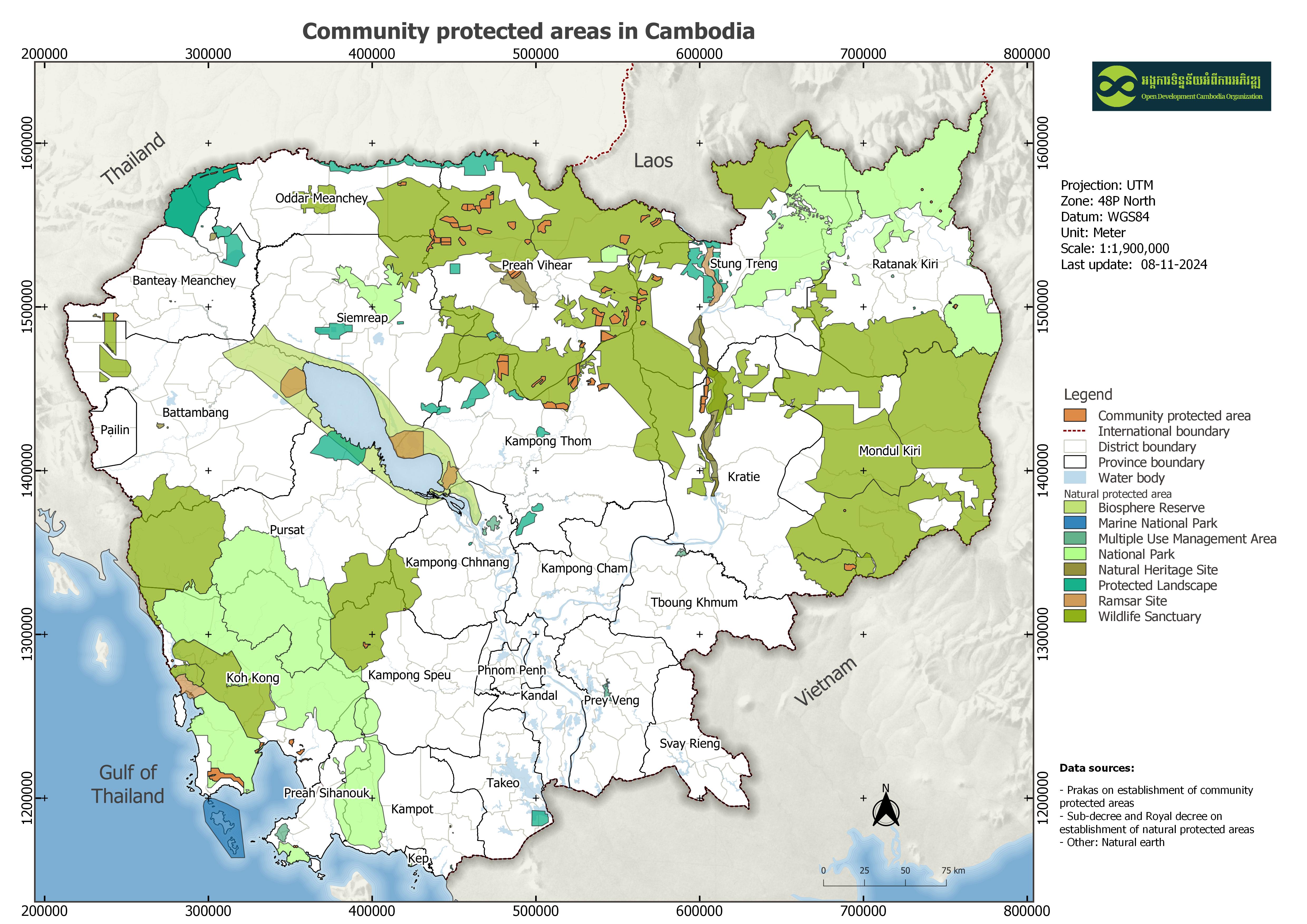
Community protected areas
Published by: Open Development Cambodia
Data Resources (7)
Data Resource Preview - Community protected areas
Thông tin khác
| Miền | Giá trị |
|---|---|
| Loại chủ đề của bộ dữ liệu |
|
| Ngôn ngữ |
|
| Hạn chế truy cập và sử dụng | By accessing this website or database, users agree to take full responsibility for reliance on any site information provided and to hold harmless and waive any and all liability against individuals or entities associated with its development, form and content for any loss, harm or damage suffered as a result of its use. |
| Ngày tham chiếu của bộ dữ liệu | 2 tháng 4, 2019 |
| Ngày mở đầu của phạm vi tạm thời | 21 tháng 6, 2006 |
| Ngày kết thúc của phạm vi tạm thời | 31 tháng 12, 2020 |
| Cơ sở dữ liệu dịa lý |
|
| Các tọa độ ranh giới phía Tây | 102.54859870122804 |
| Các tọa độ ranh giới phía Đông. | 107.38900215119163 |
| Các tọa độ ranh giới phía Nam. | 10.496327885971324 |
| Các tọa độ ranh giới phía Bắc. | 14.344214200747942 |
| Hệ tham chiếu không gian | WGS 84 / UTM zone 48N (EPSG:32648) |
| Độ chính xác định vị | The data is manually digitized from the scan documents. |
| Tính nhất quán logic | There is no logical consistency. |
| Tính đầy đủ | This dataset contains all of the data that is currently available to Open Development Cambodia (ODC) and is not exhaustive. ODC takes every effort to ensure that the details in this map are accurate and up to date. |
| (Các) quy trình thu thập và xử lý dữ liệu | The available data was collected by ODC from the government both in PDF and hardcopy format. The data format was scan and transformed to shapefile format by geo referencing, and digitizing. The data in shapefile format was finally exported to HTML, KML, and GEOJSON files. |
| (Các) nguồn | Royal Gazette from government of Cambodia, Sub-decree and Prakas, from 2006-2019 |
| Liên hệ | Ministry of Environment Address: Morodok Techo building, Lot #503, Sangkat Tonlebasak, Khan Chomkarmon, Phnom Penh, Cambodia. Email: info@moe.gov.kh, Phone: (+855) 23 213 908, (+855) 23 220 369, Fax: 023 212 540 |
| Thông tin người tạo Metadata. | Metadata last updated on 2025-08-07. For inquiries contact: Open Development Cambodia, Email: contact@opendevcam.net, Website: http://www.opendevcam.net Address: 23B St.606, Phnom Penh, Cambodia |
| Thuộc tính | name: community name; size_ha: size in hectare; npa_name: natural protected areas name; village:village name; commune: commune name; district: district name; province: province name; issued_dat: issued date; reference: referencing documents |
| Giấy phép | Creative Commons Attribution |
| Bản quyền | Yes |
| Phiên bản | 1.0 |
| Các từ khóa | CPA,community protected areas |
| Ngày đăng tải | tháng 6 11, 2018, 09:41 (UTC) |
| Ngày chỉnh sửa, cập nhật | tháng 5 4, 2026, 03:15 (UTC) |