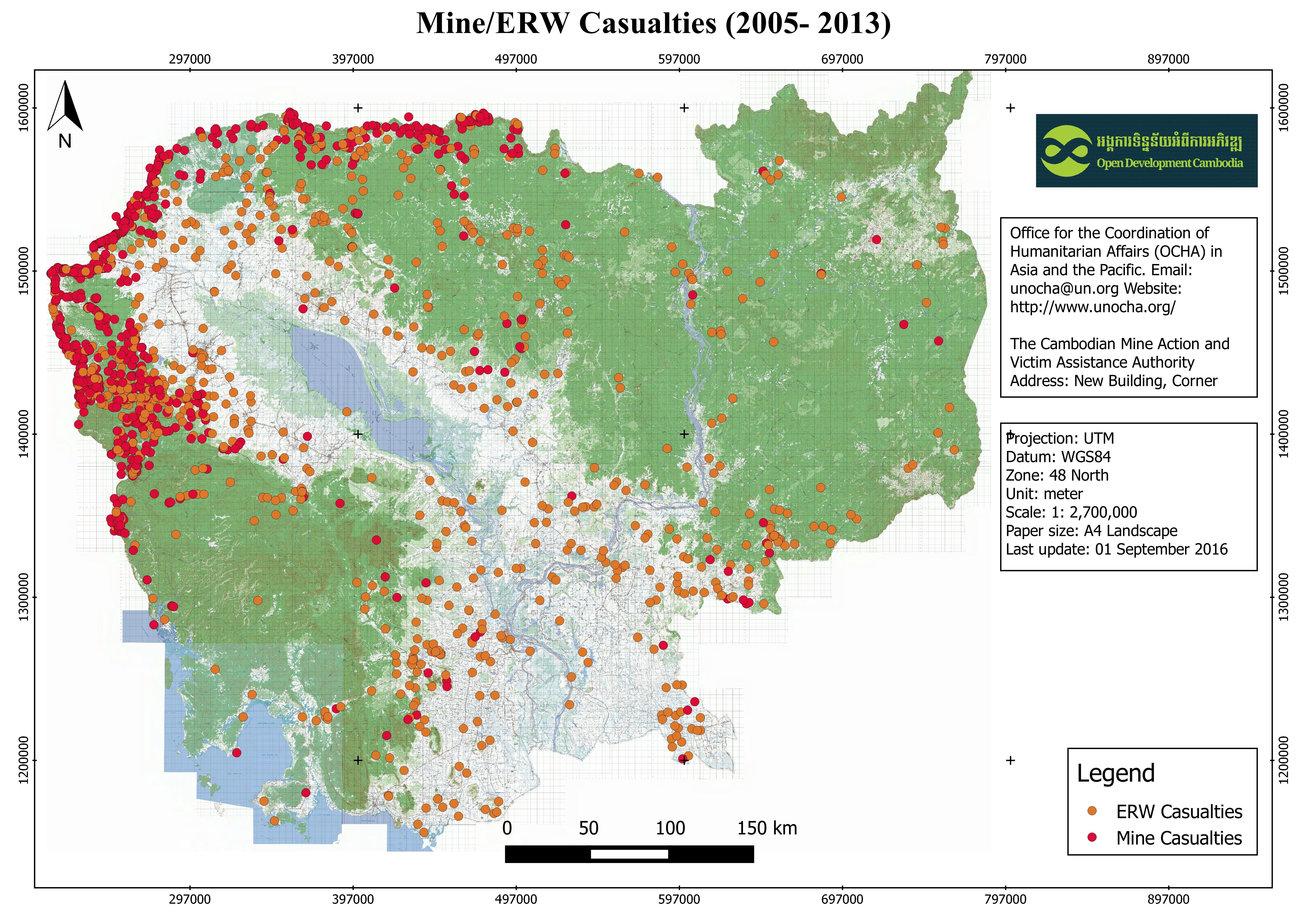
Mine/ERW casualties (2005- 2013)
Published by: Open Development Cambodia
Data Resources (8)
Data Resource Preview - Mine/ERW casualties (2005- 2013)
Thông tin khác
| Miền | Giá trị |
|---|---|
| Loại chủ đề của bộ dữ liệu |
|
| Ngôn ngữ |
|
| Hạn chế truy cập và sử dụng | By accessing this website or database, users agree to take full responsibility for reliance on any site information provided and to hold harmless and waive any and all liability against individuals or entities associated with its development, form and content for any loss, harm or damage suffered as a result of its use. |
| Ngày tham chiếu của bộ dữ liệu | 1 tháng 1, 2013 |
| Ngày mở đầu của phạm vi tạm thời | 1 tháng 1, 2005 |
| Ngày kết thúc của phạm vi tạm thời | 1 tháng 1, 2013 |
| Cơ sở dữ liệu dịa lý |
|
| Các tọa độ ranh giới phía Tây | 102.336029052734 |
| Các tọa độ ranh giới phía Đông. | 107.443817138672 |
| Các tọa độ ranh giới phía Nam. | 10.4554433822632 |
| Các tọa độ ranh giới phía Bắc. | 14.4457607269287 |
| Hệ tham chiếu không gian | WGS 84 (EPSG:4326) (CRS:84) |
| Độ chính xác định vị | The baseline data was collected from OCHA website, and ODC cannot guarantee for its accuracy. |
| (Các) quy trình thu thập và xử lý dữ liệu | Open Development Cambodia (ODC) downloaded the data from HDX (https://data.humdata.org) as ESRI shapefile. In addition to the existing file format, ODC's map and data team also created three more additional extensions: CSV, GeoJSON and KML for download. The team used CartoDB to make the data visualization layer and added the result onto ODC map explorerhttps://opendevelopmentcambodia.net/map-explorer. |
| (Các) nguồn | Office for the Coordination of Humanitarian Affairs (OCHA) in Asia and the Pacific. Email: unocha@un.org Website: http://www.unocha.org/ The Cambodian Mine Action and Victim Assistance Authority Address: New Building, Corner Street 273 & 516, Tuol Kork Village, Tuol Sangke Quarter, Phnom Penh, Cambodia Phone / Fax: (+855) 23 880 462/ 228 265, E-mail: info@cmaa.gov.kh, Website: www.cmaa.gov.kh |
| Liên hệ | Humanitarian Data Exchange (HDX) Email: hdx@un.org . Website: https://data.humdata.org/ |
| Thông tin người tạo Metadata. | Metadata last updated on 2016-09-27. For inquiries contact: Open Development Cambodia (ODC). Address: #43 St. 208, Phnom Penh, Cambodia. Email: contact@opendevcam.net Website: http://www.opendevcam.net |
| Thuộc tính | Incident_D :Incident date, ProvCode: Province code, Province: Name of province, DisCode: District code, District: District code, ComCode: Commune code, Commune: Name of commune, VilCode: Village Code, Village: Name of village, Landuse: Type of mine on land use, VICTIM: Number of victim, INJURE : Number of injured, AMPUTATION : Number of amputation, KILLED: Number of killed, DEVICES: Device of explosion, ERW_TYPE: ERW Type, MINE_TYPE: Type of mine |
| Giấy phép | Creative Commons Attribution |
| Bản quyền | Yes |
| Phiên bản | 1.0 |
| Ngày đăng tải | tháng 10 19, 2016, 01:51 (UTC) |
| Ngày chỉnh sửa, cập nhật | tháng 6 30, 2020, 16:44 (UTC) |