Phnom Penh urban sprawl timeline (2003-2013)
Published by: Open Development Cambodia
Data Resources (2)
Data Resource Preview - Phnom Penh urban sprawl timeline (2003)
Thông tin khác
| Miền | Giá trị |
|---|---|
| Loại chủ đề của bộ dữ liệu |
|
| Ngôn ngữ |
|
| Ngày tham chiếu của bộ dữ liệu | 19 tháng 6, 2014 |
| Ngày mở đầu của phạm vi tạm thời | 6 tháng 12, 2015 |
| Ngày kết thúc của phạm vi tạm thời | 6 tháng 12, 2015 |
| Cơ sở dữ liệu dịa lý |
|
| Độ chính xác định vị | There are no known issues with accuracy. |
| Tính nhất quán logic | There are no known issues with logical consistency. |
| Tính đầy đủ | The data is complete. |
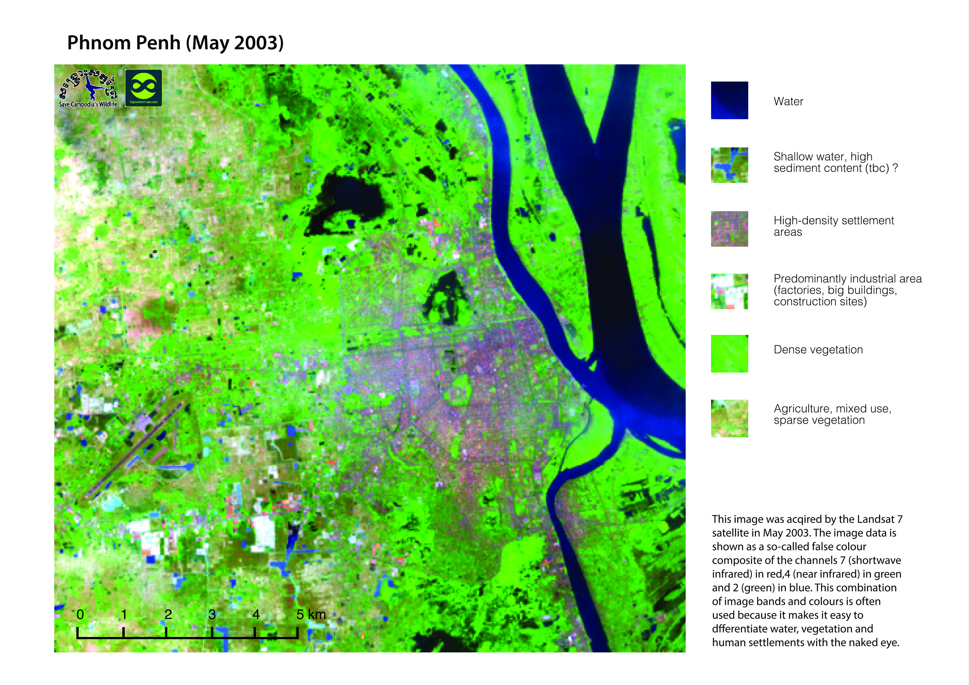
| (Các) quy trình thu thập và xử lý dữ liệu | Images from satellite Landsat 7 (2003) and Landsat 8 (2013) are presented using false colour composite channels 7 in red (shortwave infrared), 5 in green (near infrared), 3 in blue (green). The combination of image bands and colour allow easy distinction between water, vegetation and urban areas. Images were provided to Open Development Cambodia directly by Save Cambodia's Wildlife's 2013 Atlas Working Group in JPEG format. |
| (Các) nguồn | Landsat NASA 2003/13 http://landsat.gsfc.nasa.gov/ |
| Liên hệ | Save Cambodia's Wildlife (SCW), info@cambodiaswildlife.org, +855 23 88 20 35, http://cambodiaswildlife.org, 6Eo St. 570, Sangkat Boeung Kak 2, Khan Tuol Kork, Phnom Penh, Cambodia. |
| Thông tin người tạo Metadata. | Metadata last updated on 2015-12-06. For inquiries contact: Open Development Cambodia, contact@opendevcam.net, +855 23 221 164, http://www.opendevelopmentcambodia.net, 43 St. 208, Sangkat Boeung Riang, Khan Daun Penh, Phnom Penh, Cambodia. |
| Giấy phép | CC-BY-4.0 |
| Bản quyền | No |
| Phiên bản | 1.0 |
| Ngày đăng tải | tháng 12 6, 2015, 23:41 (UTC) |
| Ngày chỉnh sửa, cập nhật | tháng 6 12, 2018, 07:36 (UTC) |